OUTFLOW PROJECT USES WEATHER DRONES TO MEASURE ATMOSPHERE AHEAD OF SUMMER STORMS IN OKLAHOMA, TEXAS
Scientists from the National Severe Storms Laboratory and Cooperative Institute for Severe and High-Impact Weather Research and Operations (CIWRO) at the University of Oklahoma will embark on a new field study this summer to collect lower atmospheric observations prior to severe thunderstorms.
This story first appeared on NSSL News, written by Wes Moody.
Weather drones to measure atmosphere ahead of summer storms in Oklahoma, Texas
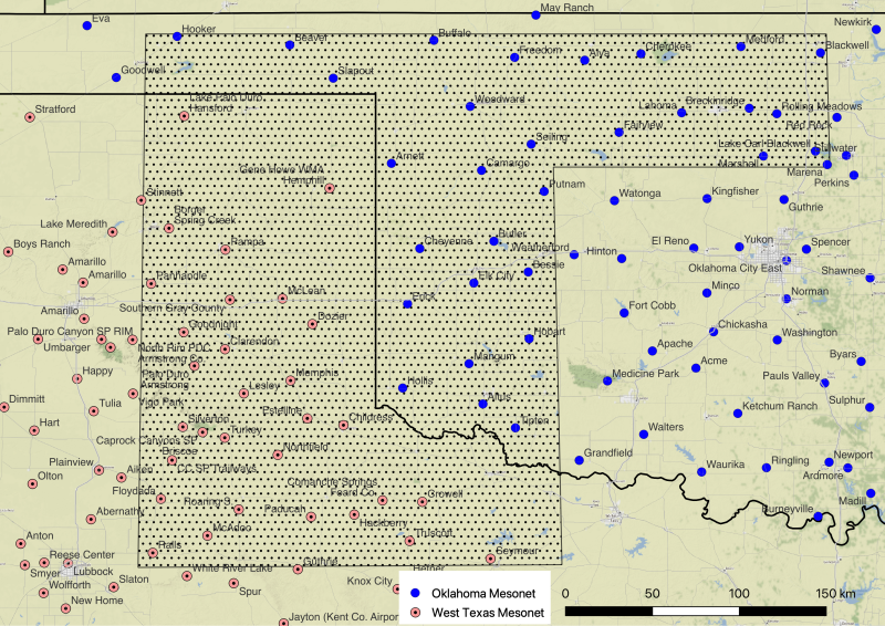
Scientists from the National Severe Storms Laboratory and Cooperative Institute for Severe and High-Impact Weather Research and Operations (CIWRO) at the University of Oklahoma will embark on a new field study this summer to collect lower atmospheric observations prior to severe thunderstorms. The project, Oklahoma UAS Targeted Flights for Low-level Observations of Weather (OUTFLOW), will concentrate on portions of northern and western Oklahoma and the Oklahoma and Texas Panhandles. OUTFLOW is funded by the National Oceanic and Atmospheric Administration (NOAA) Weather Program Office.
WHY OUTFLOW?
Weather is often driven by atmospheric conditions such as temperature, moisture and winds just above the ground, an area known as the boundary layer. These boundary layers help to determine when and where storms may form, as well as their potential hazards. As conditions near the ground can change rapidly, researchers expect more frequent sampling will improve the accuracy of severe weather forecasts. New drone technology now allows researchers to gather this more detailed data just before storms begin.
WHAT IS OUTFLOW?
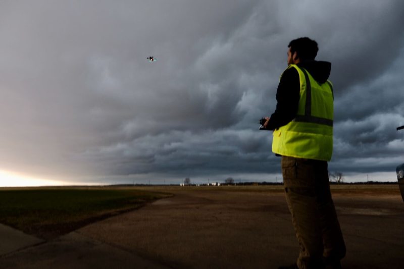
During OUTFLOW, researchers will observe the rapidly changing boundary layer, roughly the lowest kilometer of the atmosphere. Observations will occur near Oklahoma and west Texas mesonet stations using piloted CopterSondes, uncrewed aircraft systems (UAS) developed and built by CIWRO engineer Tony Segalés. Researchers’ goals are to utilize OUTFLOW observations to demonstrate a prototype 3-D mesonet concept and assimilate those observations into NOAA’s Warn-on-Forecast System (WoFS).
THE IMPACT
Nusrat Yussouf, a senior research scientist at CIWRO and the NOAA National Severe Storms Laboratory (NSSL), is the principal investigator for OUTFLOW. She believes the better representation of the near-storm environment in WoFS using the CopterSonde vertical profiles will improve the prediction of severe convective weather.
“We have observations at the surface, but there is a need to see how the boundary layer evolves when storms form. Currently we have National Weather Service balloon launches, which occur every 12 hours, and it’s very sparse. We don’t get a complete 3-D picture of the atmosphere frequently. The 3-D mesonet measurement will help us get that,” Yussouf said.
THE DETAILS
Researchers anticipate eight daytime operating periods for OUTFLOW, during the period of May 15 to Aug. 30, 2023. Four flight teams will monitor four different locations simultaneously through vertical-profile flights up to eight hours long. CopterSondes collect measurements of moisture, temperature and air pressure, and use a unique “wind vane mode” algorithm, which commands the CopterSonde to always face into the wind. This feature is essential to ensuring accurate measurements.
Tyler Bell, a research scientist at CIWRO and NOAA NSSL, will lead the field portion of the project. He will be responsible for recruiting and training students and other researchers as well as securing the necessary permissions to fly the CopterSondes.
“Having four CopterSondes flying simultaneously is an enormous challenge both in terms of personnel and staying safe in the national airspace. However, we feel the data collected from the CopterSondes will provide a huge benefit to both models and forecasters. Multiple flight locations allow us to quantify how the lower atmosphere is changing both in time and space,” Bell said.
Dr. Antonio R. Segales
Research Engineer
My research centers around developing small unmanned aircraft systems for adaptive atmospheric sampling which involves CAD modeling, systems optimization, hardware and software integration, and control theory. I have led the design of the CopterSonde series of vehicles, which is used to perfrom controlled and targeted weather sampling at high temporal and spatial resolutions. I am also advising other projects in which sensor integration or new UAS are required.
Dr. Tyler M. Bell
Research Scientist
Tyler is a Research Scientist in CIWRO working on using ground-based remote sensors and WxUAS to advance the understanding of various boundary layer processes. He is acitvely exploring ways to optimally combine data collected from WxUAS and ground-based remote sensing.